Introduction
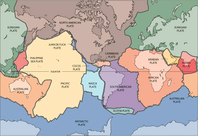
South American plate is a relatively large sized plate located below the continent, South America. South American plate is bounded by African plate in the east, Nazca plate in the west, Antarctic plate and Scotia plate in the south, and Caribbean plate and North American plate in the north. South American plate is involved in Andes Mountains formation with Nazca plate, and Mid Atlantic Ridge formation with African plate.
http://pubs.usgs.gov/gip/dynamic/slabs.html
history
A supercontinent, Pangea, formed approximately 300 million years ago in the Paleozoic era (Lovett, 2008), and it began to break apart 200 million years ago (Condie 1989). South American plate is one of the plates Pangea broke apart to.
There are several evidence for the continental drift, including: Euler’s theorem (angular rotation causes plate movements), paleoclimatology (latitude determines climate. By studying climate in ancient rocks, it is possible to determine latitude of a location in the past), and paleomagnetism (studying ferromagnetic rocks to check the magnetic field in the past). Many evidence suggest that South American plate broke apart from Pangea. (Kearey et al, 2009)
There are several evidence for the continental drift, including: Euler’s theorem (angular rotation causes plate movements), paleoclimatology (latitude determines climate. By studying climate in ancient rocks, it is possible to determine latitude of a location in the past), and paleomagnetism (studying ferromagnetic rocks to check the magnetic field in the past). Many evidence suggest that South American plate broke apart from Pangea. (Kearey et al, 2009)
Plate Motions
Nazca plate has converged with South America for the past 70 million years with varying relative motion, the fastest being 100mm/year (between 49.5 to 42 million years ago, and since 26 million years ago), and at slower times 50-55mm/year. Rapid subduction in northern Andes than the south could have led to greater Andes’ width in Peru and Boliva over Chile and Argentina (Pardo-Casas and Molnar, 1987).
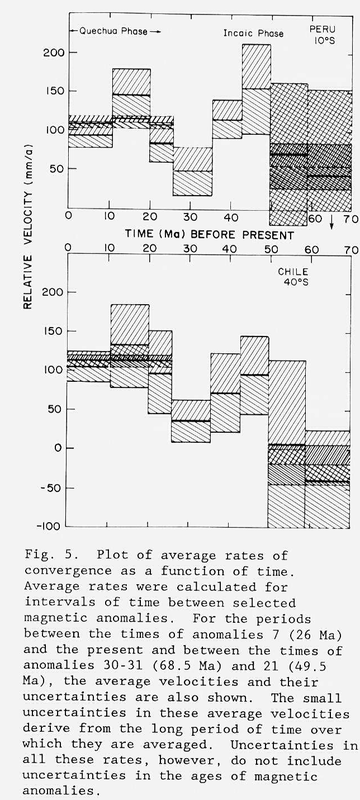
(Pardo-Casas and Molnar, 1987)
There is a sequence composed of four periods of contrasting relative motion starting in Late Triassic that describes the relative motion of South American plate away from North American plate (Ladd, 1975). Tectonic feature of each sequence developed in the Caribbean region; however, a direct cause and effect from only the late Tertiary can be seen in terms of convergent motion of South America and North America, resulting in north south compression across the northern and southern boundaries of the Caribbean (Ladd, 1975). Relative plate motions can be calculated by using global positioning system to the accuracy of 1-2mm/year. The Caribbean plate moves approximately due west relative to South American plate at a rate of 20mm/year (Perez et al., 2001).
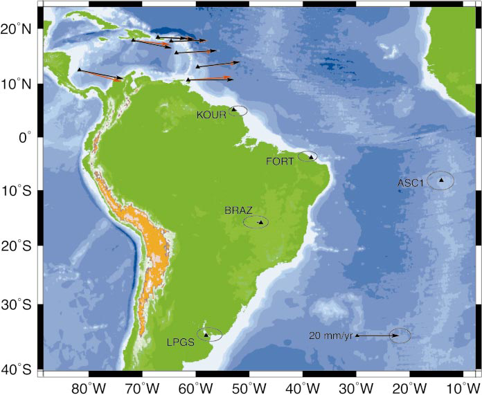
Black arrows represent observed relative motion between Caribbean and South American plates. Red arrows represent predicted relative motion between Caribbean and South American plates.
(Weber et al, 2001)
Spreading rate and spreading direction in the southeast Pacific are increasing (Somoza 1998).
andes mountains
South American plate and Nazca Plate share the longest convergent boundary on earth, featuring Andes Mountains which extends over 7000km. (Khazaradze and Klotz, 2003). Nazca plate’s melt subducts below the South American plate, causing crustal dilation which then uses the Paleozoic sedimentary rocks to compress and form fold and thrust belt. (James, 1971)
Andes Mountains is currently a home to more than 200 potentially active volcanoes as Nazca plate and South American plate still converges today. Active volcanoes are more likely to occur in convergence boundaries with relatively steep angle of subduction (Stern, 2004)
Flat slab subduction (slab subducts nearly horizontal) occurs in South American plate and Nazca plates. As a result, 4 Andean Volcanic Belts form (Jordan et al., 1982). They are: Northern Volcanic Zone, Central Volcanic Zone, Southern Volcanic Zone, and Austral Volcanic Zone.
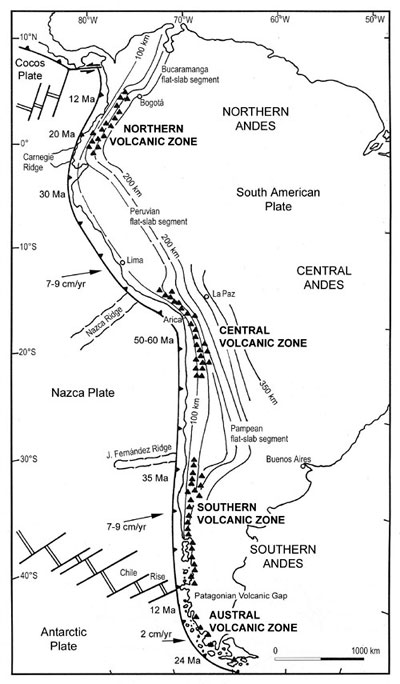
Map of 4 Andes volcanic belts. Black triangles represent active volcanoes, arrows represent relative plate motion of Nazca plate with respect to South American plate, years on Nazca plate represent the oceanic plate ages, and the contoured lines represent the depth of Benioff seismic zone.
(Stern, 2004)
Reference
Ladd, John W. “Relative motion of South America with respect to North America and Caribbean tectonics” (1975):
Somoza R. “Updated Nazca (Farallon)---South America relative motions during the last 40 My: implications for mountain building in the central Andean region” Journal of South American Earth Sciences 11, no. 3 (1998): 211-215.
Jordan, Teresa E., Bryan L. Isacks, Ricahrd W. Allmendinger, Jon A. Brewer, Victor A. Ramos, and Clifford J. Ando. "Andean tectonics related to geometry of subducted Nazca plate." (1982)
Pardo-Casas, Federico, and Peter Molnar. "RELATIVE MOTION OF THE NAZCA (FARALLON) AND SOUTH AMERICAN PLATES SINCE LATE CRETACEOUS TIME." TECTONICS 6, no. 3 (1987): 233-248.
Perez, Omar J., Roger Bilham, Rebecca Bendick, Jose R. Velandia, Napoleon Hernandez, Carlos Moncayo, Melvin Hoyer, and Mike Kozuch. "Velocity field across the southern Caribbean plate boundary and estimates of Caribbean/South-American plate motion using GPS geodesy 1994-2000." GEOPHYSICAL RESEARCH LETTERS 28, no. 15 (2001): 2987-2990.
Lovett, Richard A. (September 5, 2008). "Supercontinent Pangaea Pushed, Not Sucked, Into Place”. National Geographic News.
Plate Tectonics and Crustal Evolution, Third Ed., 1989, by Kent C. Condie, Pergamon Press
Khazaradze, Giorgi, and Jurgen Klotz. "Short and long-term effects of GPS measured crustal deformation rates along the South-Central Andes." JOURNAL OF GEOPHYSICAL RESEARCH 108 (2003): 1-13.
James, David E. "Plate Tectonic Model for the Evolution of the Central Andes." (1971)
Stern, Charles R. "Active Andean volcanism: its geologic and tectonic setting." Revista Geológica de Chile 31, no. 2 (2004): 161-206.
Kearey, P., Keith A. Klepeis, and F. J. Vine. Global Tectonics, 3rd ed. Oxford: Wiley-Blackwell, 2009
Weber, John C., et al. "GPS estimate of relative motion between the Caribbean and South American plates, and geologic implications for Trinidad and Venezuela." (2001)
