(Dutch 2009)
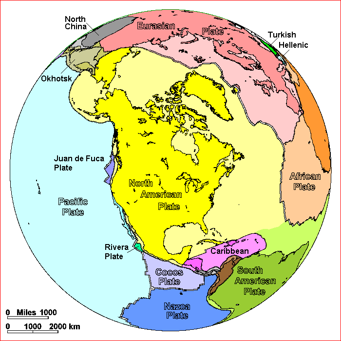
The North American
tectonic plate, shown above, encompasses the majority of the surface area of
North America, as well as Greenland, the northern Caribbean, and parts of
Siberia (Russia), Iceland, and the Azores (Portugal). (Dutch, 2009) The large plates with which it is in
contact are the Eurasian, African, South American, Caribbean, Cocos, Rivera,
Gorda, Juan de Fuca, Explorer, Pacific, and Okhotsk plates; as the number of
neighbouring plates suggests, the North American plate is rife with tectonic
activity.
Plate Boundaries
The North American plate’s interactions with other plates generate various geologic features on its surface, from mountain belts to faults. A few noteworthy examples are detailed below.
For a complete map of tectonic plate boundaries and their velocities of activity, as well as of seafloor age, follow this link:
http://www.tectonics.caltech.edu/images/maps/seafloor_age.pdf
You can use it to follow along the plate boundaries as they’re described below.
To the east, the North American plate shares the Mid-Atlantic Ridge with the Eurasian plate. This divergent margin, offset throughout by transform faults, began spreading approximately 180 Ma ago, opening the North Atlantic Ocean (Kearey, 2009). Evidence of Mesozoic juvenile crust formation in New England can be correlated with the event (McHone, 1984).
Below, a video shows the simulation of a spreading ridge like the Mid-Atlantic Ridge with wax.
(Structural Geology RWTH Aachen, 2014)
Along the western border of the North American plate in a dextral transform fault lies the Pacific plate (Nicholson, 1994). Their contact is broken by several plates and microplates: Cocos, Rivera, Gorda, Juan de Fuca, and Explorer. Along with the Nazca plate to the west of the South American plate, these plates are what remain on the Earth’s surface of the Farallon plate, a section of basaltic oceanic lithosphere that has almost fully subducted beneath the plates composing North, Central and South America (Pavlis, 2012).
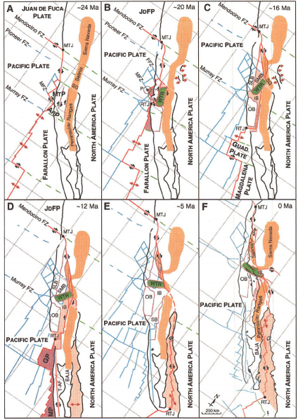
The San Andreas transform boundary between the Pacific and North American plate originates from the shallow, oblique subduction by the North American plate of the Monterey microplate (a fragment of the Farallon plate sharing a spreading ridge with the Pacific plate) (Nicholson, 1994). By 20 Ma, the Monterey-Pacific ridge stopped spreading and Monterey accreted to the Pacific plate. As a result, the Pacific plate’s motion with respect to the North American rotated, transforming a network of shallow faults into dextral transform faults (San Andreas) (Nicholson, 1994). The rotation from 24 Ma to 0 Ma is represented in the figure below, where MTP is the Monterey plate. The faults cut through California land; as a result, the Pacific plate’s annual motion 6 cm north with respect to the North American plate in the area is actively splitting the state (Marshak, 2008; Atwater, 1970).
The San Andreas transform boundary between the Pacific and North American plate originates from the shallow, oblique subduction by the North American plate of the Monterey microplate (a fragment of the Farallon plate sharing a spreading ridge with the Pacific plate) (Nicholson, 1994). By 20 Ma, the Monterey-Pacific ridge stopped spreading and Monterey accreted to the Pacific plate. As a result, the Pacific plate’s motion with respect to the North American rotated, transforming a network of shallow faults into dextral transform faults (San Andreas) (Nicholson, 1994). The rotation from 24 Ma to 0 Ma is represented in the figure below, where MTP is the Monterey plate. The faults cut through California land; as a result, the Pacific plate’s annual motion 6 cm north with respect to the North American plate in the area is actively splitting the state (Marshak, 2008; Atwater, 1970).
(Nicholson, 1994)
 (Steblov 2003)
Further north on the western North American plate margin (Juan de Fuca/North American), the Cascadia Subduction Zone’s locked megathrust fault threatens to release a high energy earthquake (Hyndman, 2010).
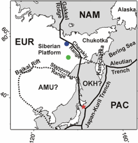
The dextral strike-slip Queen Charlotte Fault extends north of Cascadia up to Alaska (United States) (Rohr, 2000). It connects to the Aleutian Trench, a subduction zone, which runs south of Alaska into the northern margin of the Okhotsk plate towards the Chersky mountain range of eastern Siberia (Russia), as seen at right. From the Chersky Range, the North American plate boundary continues along the oceanic, divergent Gakkel Ridge, which becomes the Mid-Atlantic Ridge (Steblov, 2003).
During the Paleogene, Greenland sat on a separate plate from the North American plate and they were spread apart. (Oakey 2013) However, Greenland currently follows the motion of the North American plate, leading to a debate on whether the Greenland plate still exists disjointedly. Due to lack of evidence, a consensus on the matter has not yet been reached. (Damm 2012)
Intra-Plate Geological Features
Within the bounds of the North American plate lie several remarkable geological subprovinces. The shallow dip of the Kula plate subducting beneath the west coast of North America during the Laramide orogeny generated the Rocky Mountains far inland. (Marshak 2008) The Basin and Range Province in southwestern United States represents an area of thinned and stretched continental crust. Tertiary highlands underwent widespread normal faulting, creating horst mountains and graben valleys. The Basin and Range is believed to have formed from back-arc spreading, plume induced spreading, or from movements along the San Andreas Fault. (Wicander 2004) The Appalachians and Ouchita Mountains of the east coast are what remain of a series of mountain building events that began in the early Paleozoic. Collisions with other major plates and microplates uplifted the mountains to heights comparable to the present-day Himalayas. (Wicander 2004)
References Cited
Atwater, Tanya. "Implications of plate tectonics for the
Cenozoic tectonic evolution of western North America." Geological Society of America
Bulletin 81, no. 12 (1970):
3513-3536.
Damm, V., M. Block, K. Berglar, A. Ehrhardt, I. Heyde, M. Schnabel, B.
Schreckenberger, T. Altenbernd, and S. Suckro. "Crustal structure of the
West Greenland margin in North Baffin Bay." In EGU General
Assembly Conference Abstracts, vol. 14, p. 6077. 2012.
Dutch, Steve. “North American Plate.” Last modified December 14, 2009. http://www.uwgb.edu/s/GeolColBk/NAmerPlate.HTM.\
Hyndman, Donald W., and David W. Hyndman. Natural hazards and disasters. CengageBrain. com, 2010.
Kearey, Philip, Keith A. Klepeis, and Frederick J. Vine. Global Tectonics. Oxford: John Wiley & Sons, 2009.
Marshak, Stephen. Earth: Portrait of a Planet. New York: W. W. Norton & Company, 2008.
McHone, J. Gregory, and J. Robert Butler. "Mesozoic igneous provinces of New England and the opening of the North Atlantic Ocean." Geological Society of America Bulletin 95, no. 7 (1984): 757-765.
Nicholson, Craig, Christopher C. Sorlien, Tanya Atwater, John C. Crowell, and Bruce P. Luyendyk. "Microplate capture, rotation of the western Transverse Ranges, and initiation of the San Andreas transform as a low-angle fault system." Geology 22, no. 6 (1994): 491-495.
Oakey, Gordon N., and James A. Chalmers. "Reply to Denyszyn and Halls (this volume): Geological and geophysical observations in the Kane Basin preclude the presence of a major plate boundary in south‐western Nares Strait." Journal of Geophysical Research: Solid Earth (2013).
Pavlis, Gary L., Karin Sigloch, Scott Burdick, Matthew J. Fouch, and Frank L. Vernon. "Unraveling the geometry of the Farallon plate: Synthesis of three-dimensional imaging results from US Array." Tectonophysics 532 (2012): 82-102.
Rohr, Kristin MM, Maren Scheidhauer, and Anne M. Trehu. "Transpression between two warm mafic plates: The Queen Charlotte Fault revisited." Journal of Geophysical Research: Solid Earth (1978–2012) 105, no. B4 (2000): 8147-8172.
Steblov, G. M., M. G. Kogan, R. W. King, C. H. Scholz, R. Bürgmann, and D. I. Frolov. "Imprint of the North American plate in Siberia revealed by GPS." Geophysical research letters 30, no. 18 (2003): 1924.
Structural Geology RTWH Aachen. "Endo YouTube Challenge 2013 MOR with wax." Online video clip. YouTube. YouTube, 2013. Web. 30 Jan. 2014
Wicander, Reed, and James S. Monroe. Historical Geology. Toronto: Brooks/Cole, 2004.
