introduction
The Juan de Fuca plate is located on the west coast of North America, between the Pacific plate (to the west) and the North American plate (to the east). The Juan de Fuca plate formed during the Oligocene as a result of the Farallon plate breaking into a series of smaller plates (Govers & Meijer, 2001). Other remnants of the Farallon plate include the Explorer microplate, located to the North of the Juan de Fuca plate, and the Gorda plate, located to the South of the Juan de Fuca plate (Stock & Lee, 1994). Figure 1 shows a map with the location of plates, along with the area's geology.
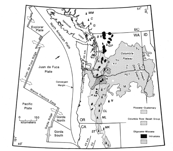
Figure 1: Geological map of the Juan de Fuca-Gorda-Explorer plate system (Swanson et al., 1989).
Geology and age
The Juan de Fuca plate is composed of young, oceanic lithosphere being generated at the Juan de Fuca ridge, not far from where the plate is being subducted under the North American plate (Rogers, 1988). The maximum age of the plate is approximately 9 Ma at the southern end and the minimum age of the plate is approximately 6 Ma around the Nootka Fault Zone (Rogers, 1988). Both the Explorer and Gorda plates are also basaltic in composition and are younger than 6 Ma (Rogers, 1988). Young lithosphere is thin, and as a result the plates are approximately less than 30 km thick, making them flexible (Rogers, 1988).
The cascade range
Partial melting of the basaltic Juan de Fuca slab as it subducts beneath the North American plate has produced a series of volcanic arcs called the Cascade Range (Priest, 1990). The Cascade Range is located along the west coast of North America, extending from British Columbia to Northern California (Swanson et al., 1989). Moving North to South down the Cascade Range, the composition of rocks formed from volcanoes becomes increasingly basaltic. There are significantly fewer rocks of andesitic to dacitic composition in the south compared to rocks in the north (Swanson et al., 1989). Figure 1 shows the geology of the Cascade Range region (Swanson et al., 1989).
Volcanism production rates around 35 Ma were higher than they have been in more recent history, corresponding with the faster rate of convergence of the plates (Priest, 1990). Around 25 Ma a deformation event occurred, tilting and faulting the rocks in the region (Priest, 1990). Volcanism production decreased around 16.9 Ma ago as the rate of plate convergence slowed down (Priest, 1990). Interestingly, approximately 7.4 Ma volcanism rates slightly increased although plate convergence rates continue to decrease (Priest, 1990). Priest believes that the stress exerted upon the upper plate is responsible for this slight increase.
Volcanism production rates around 35 Ma were higher than they have been in more recent history, corresponding with the faster rate of convergence of the plates (Priest, 1990). Around 25 Ma a deformation event occurred, tilting and faulting the rocks in the region (Priest, 1990). Volcanism production decreased around 16.9 Ma ago as the rate of plate convergence slowed down (Priest, 1990). Interestingly, approximately 7.4 Ma volcanism rates slightly increased although plate convergence rates continue to decrease (Priest, 1990). Priest believes that the stress exerted upon the upper plate is responsible for this slight increase.
plate motions
The Juan de Fuca-Gorda-Explorer plate system has all three types of plate boundaries. Both the Gorda and Explorer plates are the result of fragmentation. The Gorda plate started moving 3 million years ago while the Explorer plate started moving 5 million years ago at the southern and northern ends of the Juan de Fuca plate. Movement of these plates occurs along the Cascadia subduction zone (Stock & Lee, 1994). See figure 2 from Stock and Lee for transform zones and relative movement of both plates.
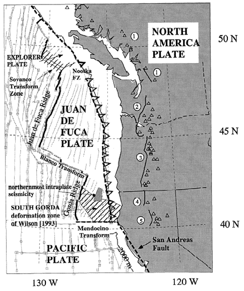
Figure 2: Transform faults and plate boundaries of the Juan de Fuca-Gorda-Explorer plate system (Stock & Lee, 1994).
Both the Juan de Fuca plate and Gorda plate are subducting beneath the North American plate in a general North-East direction. The Juan de Fuca plate is converging at a rate of approximately 40 mm/yr with the North American plate in the direction N50E (Swanson et al., 1989). Interestingly, this rate of convergence has been slowing down at a rate of 20 mm/yr to 30 mm/yr since 7 million years ago (Swanson et al., 1989).
The Juan de Fuca is spreading away from the Juan de Fuca ridge, towards the North American plate (Hyndman & Hyndman, 2010). This spreading carries oceanic material of the Juan de Fuca plate down the Cascadia subduction zone (Hyndman & Hyndman, 2010). The Juan de Fuca plate has a half spreading rate of approximately 25 mm/yr to 35 mm/yr (Govers & Meijer, 2001). This indicates that by the time to material of the Juan de Fuca plate reaches the Cascadia subduction plate boundary, the material is at most 11 Myr old (Govers & Meijer, 2001).
Watch Tanya Atwater's video of the evolution of the plates though time to get a better sense of what is going on in the region.
(Atwater, 2008)
The Gorda plate is separated from the Juan de Fuca plate by a transform boundary along the Blanco Fracture zone (see figure 2) and the Explorer plate is separated by the Sovanco transform zone (Stock & Lee, 1994). The San Andreas fault is a transform fault which runs 1200 km along the west coast of North America (Hyndman & Hyndman, 2010). The interaction of the Gorda plate, North American plate and Pacific plate form the Mendocino triple junction (Atwater, 1989). This triple junction has been drifting up the coast of North America for the past 27 Ma (Atwater, 1989). Figure 3 from Atwater, 1989, depicts the migration of the Mendocino triple junction. Figure 4A shows the geometry of a stable triple junction, where one fault and the trench are colinear (Atwater, 1989). 4B illustrates the current geometry of the Mendocino triple junction (Atwater, 1989). Note that the junction is unstable.
The interactions of the Gorda, North America and Pacific plates at the Mendocino Triple Junction make it a seismically active area. Approximately 80 magnitude 3 earthquakes have occured at the triple junction every year since 1983 (Oppenheimer, 2013). There have also been some greater magnitude earthquakes that occurred in the area in the past, such as the Cape Mendocino earthquake of 1992 (Oppenheimer, 2013). For more information on seimicity in the area, click here.
The interactions of the Gorda, North America and Pacific plates at the Mendocino Triple Junction make it a seismically active area. Approximately 80 magnitude 3 earthquakes have occured at the triple junction every year since 1983 (Oppenheimer, 2013). There have also been some greater magnitude earthquakes that occurred in the area in the past, such as the Cape Mendocino earthquake of 1992 (Oppenheimer, 2013). For more information on seimicity in the area, click here.
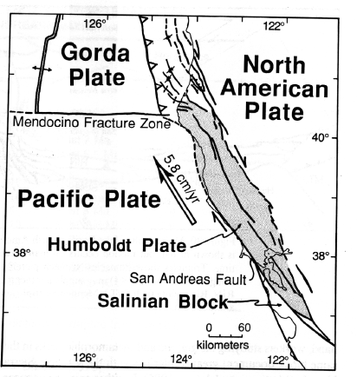
Figure 3: Migration of the Mendocino Triple Junction (Atwater, 1989).
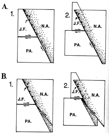
Figure 4A: Geometry of a stable triple junction. 4B: Geometry of the current unstable Mendocino triple junction (Atwater, 1989).
Interesting Feature: Slab window
Slab windows occur where triple junction settings are present. They are caused by the subduction of a spreading ridge beneath the continental crust (McCrory et al., 2009). A gap opens up between two downward moving oceanic plates and the asthenosphere migrates upwards to fill in the newly created gap. The upwelling asthenosphere causes an increase in heat flow of the lithosphere, initiating volcanism representative of both asthenosphere and lithosphere sources (McCrory et al., 2009). Figure 5 illustrates the formation of a slab window (McCrory et al., 2009).
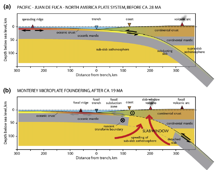
Figure 5: The formation of a slab window. Note the in 5b, asthenosphere rises to fill in the gap, creating new volcanism (McCrory et al., 2009).
cascadia megathrust Earthquake
The Cascadia Subduction Zone is the most important subduction zone in North America. An active subduction zone extends up the west coast for approximately 1200 km, from northern California to British Columbia (Hyndman & Hyndman, 2010). Subduction of the oceanic lithoshpere from the Juan de Fuca plate through an oceanic trench at the Cascadia Subduction zone can create earthquakes at depths up to hundreds of kilometers (Hyndman & Hyndman, 2010).
Geologists have been able to determine that the last earthquake to occur along the Cascadia Subduction Zone occurred around the year 1700. This age was determined by radiocarbon dating of the peat and buried trees of the region, along with counting of the tree rings (Hyndman & Hyndman, 2010). Historical records indicate that waves approximately 2 meters in height hit the coast of Japan at around the same time and archeological digs have confirmed this (Hyndman & Hyndman, 2010). This evidence indicates that the Cascadia Megathrust released enough energy to generate a tsunami (Hyndman & Hyndman, 2010).
In order to generate waves of such magnitude, it is likely that the entire 1200 km fault ruptured at once (Hyndman & Hyndman, 2010). This would have generated an earthquake of approximately magnitude 9, although no records exist from the time of rupture (Hyndman & Hyndman, 2010). Radiocarbon dating techniques determined that there have been 7 megathrust earthquakes around Washington and as many as 12 in other areas along the coast (Hyndman & Hyndman, 2010). From this information, it can be seen that the Megathrust Earthquake has a recurrence interval ranging anywhere from 250 years to 900 years (Hyndman & Hyndman, 2010). Rogers related the width and length of rupture of different segments along the subduction zone to estimate the maximum magnitude of future earthquakes. He determined that there could potentially be a magnitude 8.5 earthquake along the Explorer segment, a magnitude 9.1 along the Juan de Fuca Segment and a magnitude 8.3 along the South Gorda segment (Rogers, 1988). Approximately 300 years have passed since the magnitude 9 Cascadia Megathrust of 1700, and another one could occur at any time. Such an event would be catastrophic, damaging much infrastructure and affecting the lives of millions of people.
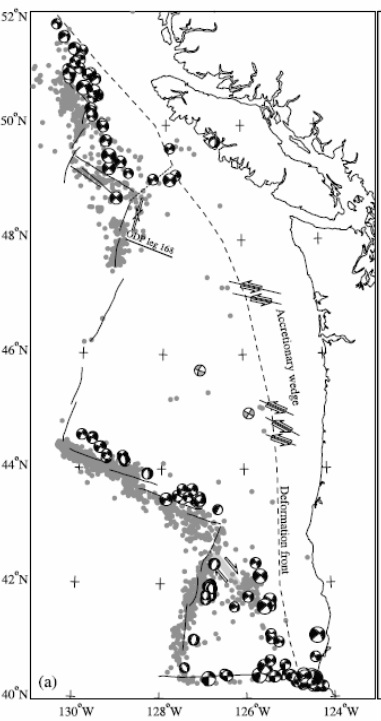
Figure 6: Focal mechanisms of past earthquakes along the Cascadia subduction zone from the years 1977 to 2000. Grey circles represent the epicenters of historic earthquakes during the years 1991-1993 and 1998-1999 (Govers & Meijer, 2001).
references
Atwater, T. (1989). Plate tectonic history of the northeast pacific and western north america. The Geological Society of America, Vol. N, The Eastern Pacific Ocean and Hawaii, 21-72.
Atwater, T. "An Animated Tectonic History of Western North America and Southern California." Online video clip. Youtube. Youtube, Dec. 2008. Web. 16 Jan. 2014
Govers, R., & Meijer, P. T. (2001). On the dynamics of the juan de fuca plate. Earth and Planetary Science Letters, 189(3-4), 115-131.
Hyndman, D. W., & Hyndman, D. W. (2010). Natural hazards and disasters. Brooks/Cole Cengage Learning.
McCrory, P. A., Wilson, D. S., & Stanley, R. G. (2009). Continuing evolution of the Pacific–Juan de Fuca–North America slab window system—A trench–ridge–transform example from the Pacific Rim. Tectonophysics, 464(1), 30-42.
Oppenheimer, D. (2013, 01 14). Mendocino triple junction offshore northern california. Retrieved from http://woodshole.er.usgs.gov/operations/obs/rmobs_pub/html/mendocino.html
Priest, G. R. (1990). Volcanic and tectonic evolution of the Cascade volcanic arc, central Oregon. Journal of Geophysical Research: Solid Earth (1978–2012),95(B12), 19583-19599.
Rogers, G. C. (1988). An assessment of the megathrust earthquake potential of the Cascadia subduction zone. Canadian Journal of Earth Sciences, 25(6), 844-852.
Stock, J. M., & Lee, J. (1994). Do microplates in subduction zones leave a geological record?. Tectonics, 13(6), 1472-1487.
Swanson, D. A., Cameron, K. A., Evarts, R. C., Pringle, P. T., & Vance, J. A. (1989). IGC Field Trip T106: Cenozoic Volcanism in the Cascade Range and Columbia Plateau, Southern Washington and Northernmost Oregon. Field Trip Guidebooks, 106, 1-60. American geophysical union
